Saturday, December 26, 2015

Arizona's Painted Desert

Two hundred twenty million years ago the land now called Arizona sat near earth's equator. Instead of deserts it hosted dinosaurs in a tropical rainforest environment. When the forest's giant trees toppled they marinated in mineral rich water before eventually crystalizing underneath the pressure of sediments and time. Erosion now again reveals these massive tree trunk gemstones.

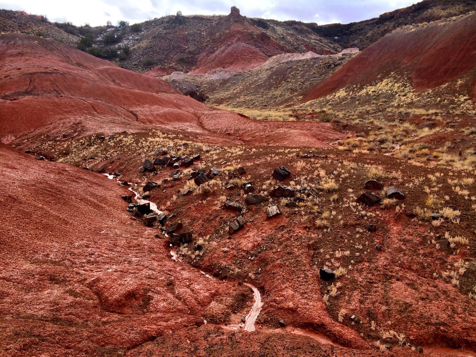
I pause at the description of Petrified Forest National Park as a "forest." It once was forest, but a forest to me calls to mind a collection of upright trees rather than felled ones. Name aside, the stumps are only the part of the appeal. Arizona's Painted Desert (not to be confused with Oregon's) sets the scene for the petrified wood. The minerals that infused the trees are still present in the soils and streak the layered dirt piles, arroyos, and hoodoos with a spectrum of colors.

My visit to Petrified Forest on Christmas eve was a two and a half hour stopover between Santa Fe, New Mexico, where I spent the prior night, and Mesa, Arizona, where I would spend the next few. I was headed to the desert to meet up with my family for the holidays. They also were driving so we met in Santa Fe and stayed at the historic La Fonda Inn just off the square where the Old Spanish Trail ends.

Petrified Forest National Park I learned when I visited contains some 50,000 acres of wilderness--land with no trails where hikers can wander aimlessly (or purposefully), occasionally stumbling upon artifacts of the prehistoric. I ventured about a half mile into this wilderness but would like to come back and go further when I have more time, the temperature is warmer, and the ground is not quite as muddy.


Saturday, December 5, 2015

Pawnee Peak

In mid-October, a friend from Texas visited Denver. We hiked to the summit of Pawnee Peak 12,943 feet above sea level along the Continental Divide.


Wednesday, November 25, 2015

Medicine Bow National Forest

On the second Friday of October, I unexpectedly found myself with the afternoon off. Over the weekend prior, I'd contemplated a trip to Wyoming's Medicine Bow National Forest but ended up not going due to work so I leapt at this new opportunity.

As the sun set on my drive north to Laramie where I'd spend the night, I stopped at Vedauwoo (pronounced vee-da-voo), a section of Medicine Bow National Forest just off Interstate 80 famous for its difficult name and strange granite formations. Here, I non-technically clambered halfway up one of the rock towers then wandered through the skeletal trees surrounding the stone gardens.

Vedauwoo's 8,200 foot elevation and chilly winds forced me to break out my down coat, a pointed reminder that after a balmy summer winter was fast approaching.

The next morning, I woke a couple hours before dawn and drove an hour west of Laramie to Lake Marie, in a different section of Medicine Bow National Forest. The quartzite mountain stands a couple thousand feet higher than the lake, topping out at 12,013 feet above sea level.

Medicine Bow Peak's massive, pillared rock face, black and gray in the pre-dawn light, glowed pink as the sun rose in the east, scoring a direct hit. In the clear light of day, the the rock resembled white marble.

The hike gains elevation quickly, meanders for awhile at just under 12,000 feet, and finally reaches the summit, a bump ever so slightly higher than the surrounding terrain. To the north, I could see Elk Mountain, not far from the interstate. To the south I could see Longs Peak, over a hundred miles away. The descent down the north side is even sharper and quicker than the climb up the south.

En route back to Denver, I made a few more short stops, including at the 60 foot tall Ames Monument, a sturdy pyramid built near the highest point along the transcontinental railroad in honor of Union Pacific financiers Oakes and Oliver Ames.